
Ukhimath to Madmaheshwar Route: Road, Villages and Trek Stages
Published on April 14, 2026 | Updated on September 14, 2026
The Ukhimath to Madmaheshwar route combines a mountain-road journey with a multi-stage trek through Ransi, Gaundar, Bantoli and smaller trail settlements before reaching Madhyamaheshwar Temple.
Ukhimath serves as the principal transportation and service center for the journey. Travelers can arrange a local vehicle, purchase essential supplies, withdraw cash and confirm road conditions before continuing toward Ransi. Ransi is the road-access point most commonly used by present-day travelers to begin the Madhyamaheshwar Trek.
The walking route then passes through traditional Garhwali settlements, forest sections, river valleys and sustained uphill terrain before reaching the temple at approximately 3,490–3,497 meters.
This guide focuses specifically on the physical route between Ukhimath, Ransi and Madhyamaheshwar. For transportation from Delhi, Haridwar, Rishikesh or Dehradun, read our separate How to reach Madhyamaheshwar guide.
Important: Road access, trail conditions, transportation availability and locally used walking stages can change. Confirm current conditions in Ukhimath or Ransi before beginning the journey.
Ukhimath to Madmaheshwar Route at a Glance
| Route section | Transportation | Route character |
|---|---|---|
| Rishikesh or Haridwar to Ukhimath | Bus, shared vehicle or private taxi | Long mountain-road journey |
| Ukhimath to Ransi | Local shared vehicle or private taxi | Narrow mountain road |
| Ransi to Gaundar | Trek | Village and forest trail with descent and ascent |
| Gaundar to Bantoli | Trek | River-valley and confluence section |
| Bantoli toward the upper trail | Trek | Sustained and physically demanding ascent |
| Upper trail to Madhyamaheshwar | Trek | Forest, open slopes and temple approach |
| Madhyamaheshwar to Budha Madhyamaheshwar | Optional trek | Shorter but steep uphill extension |
The exact stage division should be selected according to fitness, daylight, weather and confirmed accommodation.
Why Does the Madhyamaheshwar Journey Pass Through Ukhimath?
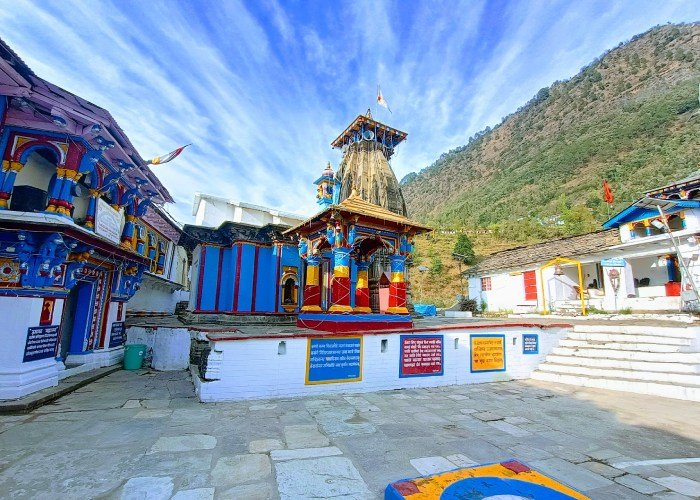
Ukhimath is one of the most important towns in the Madhyamaheshwar journey. It is both a practical travel base and a spiritually significant destination.
During winter, worship connected with Madhyamaheshwar continues at Omkareshwar Temple in Ukhimath after the high-altitude shrine closes for the season. This makes Ukhimath more than a transportation stop.
Travelers commonly use Ukhimath to:
- Arrange a vehicle toward Ransi
- Stay overnight before the trek
- Purchase food and trekking supplies
- Withdraw cash
- Check road and weather conditions
- Confirm accommodation farther along the route
- Visit Omkareshwar Temple
- Obtain recent local information
Ukhimath to Ransi: The Road Section
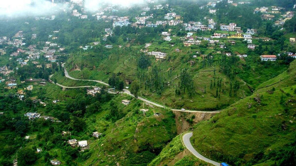
The journey from Ukhimath toward Ransi Village is completed by road. Depending on the locally operating route, the drive passes through or near settlements such as Mansoona and Uniana before reaching Ransi.
GMVN currently identifies Ransi as the point up to which travelers can take a taxi before beginning the trek. Older official descriptions sometimes calculate the pilgrimage trail from Uniana because motor-road access has changed over time.
This difference explains why online sources provide different figures for the Ukhimath-to-Ransi road distance and the total Madhyamaheshwar walking distance.
Transportation options
Travelers may find:
- Shared local jeeps
- Reserved local vehicles
- Private taxis arranged in Ukhimath
- Package transportation
- Limited seasonal services
Shared vehicles may not follow a fixed online timetable. Departure can depend on passenger demand, road conditions and the pilgrimage season.
Before leaving Ukhimath
Confirm:
- Whether the road is open to Ransi
- Latest departure time
- Exact fare
- Whether the vehicle is shared or reserved
- Luggage allowance
- Current weather
- Availability of accommodation in Ransi
- Whether a return vehicle must be arranged in advance
Do not begin the road section late during poor weather.
Why Do Madhyamaheshwar Trek Distances Differ Online?
Travelers may find Madhyamaheshwar trek distances ranging from approximately 16 km to 24 km. This does not necessarily mean that every source describes the same starting point.
The variation occurs because:
- Older routes began farther down the road.
- Current vehicles generally continue toward Ransi.
- Some measurements begin at Uniana.
- Others begin from Ransi Village.
- Some include village detours and accommodation stops.
- GPS tracks calculate turns and elevation differently.
- Route changes may occur after weather damage.
- Some figures describe one-way distance, while others describe selected daily stages.
Uttarakhand Tourism describes the broader Madhyamaheshwar trek as approximately 24 km, while many present-day travelers calculate a shorter walking distance when starting from Ransi.
Therefore, this page does not present one universal distance as exact. Confirm the currently used starting point and walking route locally.
Where Does the Walking Route Begin?
Most travelers now begin walking from Ransi Village. Ransi is a traditional Garhwali settlement with basic accommodation, food and local support.
Before starting:
- Confirm the trail condition.
- Carry sufficient cash.
- Fill water bottles.
- Keep rain protection accessible.
- Confirm the planned overnight stop.
- Ask whether accommodation is operating.
- Begin with sufficient daylight.
- Save emergency contacts offline.
- Carry identification.
- Inform someone of your expected destination.
Do not assume that mobile connectivity will remain available after Ransi.

Route Stage 1: Ransi to Gaundar Village
The trail from Ransi begins with changing gradients rather than one continuous climb. Travelers encounter a combination of descent, forested terrain, agricultural areas and later uphill sections.
The journey introduces visitors to the quieter village landscape associated with the Madhyamaheshwar pilgrimage.
Expect:
- Stone and soil paths
- Forest cover
- Uneven steps
- Descending sections
- River-valley views
- Humid conditions during monsoon
- Limited mobile connectivity
- Locally operated rest or food points
Avoid walking too quickly at the beginning. Early downhill sections can create the false impression that the complete route will be easy.
Gaundar Village: An Important Trail Settlement
Gaundar is one of the most important inhabited stops along the Madhyamaheshwar route. It provides an opportunity to rest, ask about conditions farther uphill and understand how local communities support the pilgrimage.
Depending on the season and availability, travelers may find basic food or accommodation. These services should always be confirmed rather than assumed.
At Gaundar, ask about:
- Trail conditions toward Bantoli
- Recent rainfall
- Stream levels
- Available rooms
- Food preparation time
- Conditions on the upper ascent
- Travelers who have recently descended
- Expected daylight remaining
Read the dedicated Gaundar Village travel guide before selecting Gaundar as an overnight stop.
Route Stage 2: Gaundar to Bantoli
The trail continues from Gaundar toward Bantoli through the river-valley environment. Bantoli is associated with the confluence area and is an important decision point before the sustained climb toward Madhyamaheshwar.
This section may include:
- River sounds and valley views
- Wet or slippery areas
- Narrow trail sections
- Bridges or established crossings
- Forest vegetation
- Basic local stopping points
During monsoon conditions, do not approach the river edge or leave the established trail for photographs.
Bantoli: The Transition to the Steeper Ascent
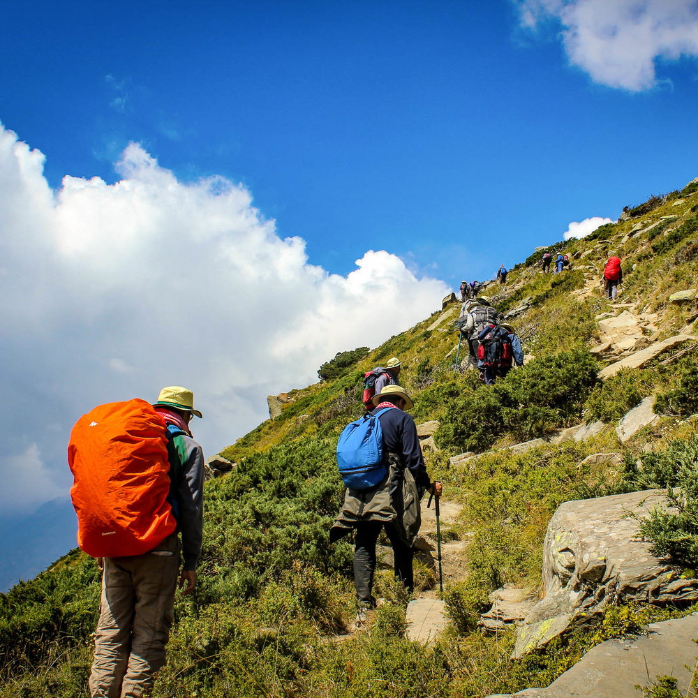
Bantoli marks an important change in the character of the journey. After this area, the route becomes more consistently uphill and physically demanding.
Travelers sometimes underestimate the section beyond Bantoli because they calculate difficulty only from total distance. Elevation gain, weather, backpack weight and walking speed matter as much as kilometers.
Before continuing from Bantoli:
- Assess the group’s energy.
- Confirm remaining daylight.
- Refill water where safe and available.
- Ask about accommodation ahead.
- Check weather conditions.
- Keep warm or waterproof layers accessible.
- Avoid continuing when anyone is unwell.
Route Stage 3: Bantoli to the Upper Trail
The ascent after Bantoli is generally considered one of the most demanding parts of the Madhyamaheshwar route. The trail climbs through a sequence of forest and mountain sections before reaching the higher temple landscape.
Names used for smaller stopping points can vary in spelling. Travelers may hear references to Upper Bantoli, Khatara, Nanu, Maikhamba and Kunchatti.
These are not full-service tourist towns. Facilities can be basic, seasonal or unavailable.
The upper route may involve:
- Long uphill stretches
- Uneven stone steps
- Forest sections
- Open slopes
- Limited resting areas
- Rapid weather changes
- Reduced communication
- Cold conditions after sunset
- Greater physical fatigue
Walk at a sustainable pace and avoid separating from the group.
Route Stage 4: Final Approach to Madhyamaheshwar Temple
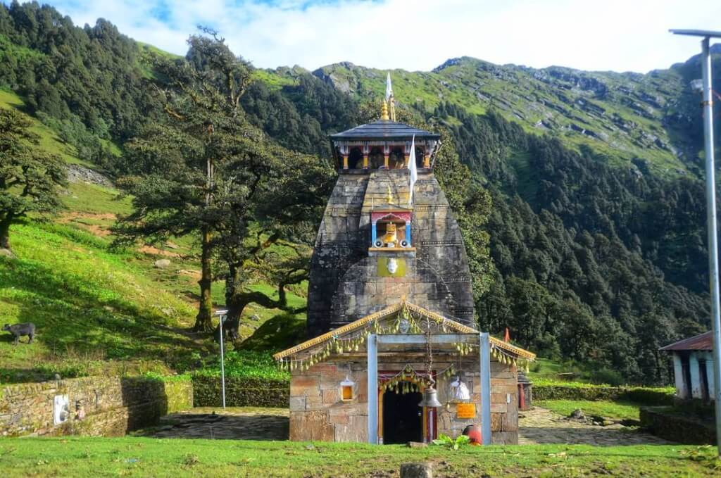
As travelers gain elevation, the surroundings gradually change from forested terrain to a more open Himalayan landscape. The final approach leads toward the Madhyamaheshwar Temple area.
Madhyamaheshwar is one of the five Panch Kedar temples and is traditionally regarded as the Second Kedar. It is associated with the middle or navel portion of Shiva’s bull form in the Panch Kedar tradition.
After arriving:
- Rest before attempting additional activities.
- Confirm accommodation immediately.
- Change out of wet clothing.
- Eat and hydrate.
- Ask about current darshan and ritual timings.
- Do not assume mobile connectivity.
- Avoid attempting Budha Madhyamaheshwar late in the day.
Use the Madhmaheshwar Temple destination page for an overview of the shrine, and read the detailed Madhyamaheshwar Temple guide for darshan, rituals and etiquette.
Optional Extension to Budha Madhyamaheshwar
Budha Madhmaheshwar is situated above the main temple and is visited for its sacred character, alpine setting and Himalayan views.
The uphill excursion is optional. It should be attempted only when:
- Weather is stable
- Visibility is adequate
- The trail has been checked locally
- The group is sufficiently rested
- There is adequate daylight
- No thunderstorm is developing
A sunrise visit requires advance preparation and local confirmation. Do not attempt it alone in darkness or fog.
Villages Along the Madhyamaheshwar Route
The villages are not merely transit points. They provide accommodation, food, route knowledge and practical support.
Travelers should:
- Respect private property.
- Ask before taking photographs.
- Avoid loud music.
- Support locally operated stays.
- Carry cash in small denominations.
- Do not expect hotel-level facilities.
- Avoid leaving waste.
- Follow local advice during poor weather.
- Allow sufficient time for freshly prepared food.
The local villages guide explains the role of settlements along the route.
How Many Days Should You Keep?
The route should not be planned as a race. The required duration depends on the starting city, transportation, fitness, accommodation choices and optional activities.
A practical schedule should include time for:
- Traveling to Ukhimath
- Staying in Ukhimath or Ransi
- Trekking toward Gaundar or Bantoli
- Completing the upper ascent
- Temple darshan
- Optional Budha Madhyamaheshwar visit
- Descending safely
- Returning from Ransi
- Weather or transportation delays
For most travelers, a five- or six-day journey from Rishikesh or Haridwar is more realistic than a compressed schedule. Families, slower walkers and first-time trekkers may require additional time.
Use the Madhyamaheshwar Trip Plan for complete duration, overnight-stop and budget planning.
Where Should You Stay?
Possible overnight bases include:
Ukhimath
Suitable for transportation, supplies, better accommodation choices and a visit to Omkareshwar Temple.
Ransi
Suitable for travelers who want an early start from the road-access point.
Gaundar
A possible village stop depending on room availability and the group’s pace.
Bantoli or another confirmed trail stop
Useful for dividing the trek before the sustained upper ascent.
Near Madhyamaheshwar Temple
Allows more time for darshan and an optional morning visit to Budha Madhyamaheshwar.
Facilities become increasingly basic along the trail. Confirm availability before depending on a particular stop.
Best Time for the Ukhimath to Madmaheshwar Route
The practical trekking season is connected to the seasonal opening of Madhyamaheshwar Temple.
May and June
These months may provide pleasant daytime walking conditions, but early-season snow or rain can still affect higher sections.
July and August
Monsoon rain can cause slippery trails, road delays, fog, stronger streams and landslide risk. This is not the preferred period for first-time trekkers.
September and October
Post-monsoon conditions often provide clearer views and more stable walking conditions. Nights become colder at higher elevations.
Late season
Temperatures fall as the temple-closing period approaches. Early snow is possible, and services may reduce near the end of the pilgrimage season.
Check the Madhyamaheshwar weather guide before selecting your dates.
Route Safety Essentials
Begin early
Early departures provide more daylight and time for unexpected delays.
Protect your knees
Long descents can strain the knees. Trekking poles and a controlled pace can help.
Do not ignore altitude symptoms
Altitude-related illness can occur below 4,200 meters. There is no universally safe elevation. Persistent headache, nausea, dizziness, confusion, poor coordination or breathlessness at rest requires immediate attention.
Do not climb higher when symptoms are worsening.
Carry adequate water
Do not drink untreated water merely because it comes from a mountain stream. Use a reliable purification method.
Keep weight manageable
An unnecessarily heavy backpack increases fatigue on the long ascent beyond Bantoli.
Prepare for communication gaps
Download offline information and share the itinerary before leaving the connected area.
Follow local advice
Local residents and travelers descending from the upper trail may have more recent information than an online forecast.
Packing Essentials
Carry:
- Broken-in trekking shoes
- Trekking poles
- Rain jacket
- Warm layers
- Backpack rain cover
- Waterproof inner bags
- Headlamp
- Extra socks
- Personal medication
- First-aid supplies
- Water-treatment method
- Energy food
- Power bank
- Identification
- Cash
- Offline map
- Emergency contacts
Use the complete Madmaheshwar packing guide for a detailed checklist.

Plan the Route with TourMyHoliday
Travelers who prefer transportation, accommodation, selected meals and trek support arranged together can review the Madmaheshwar Trek Package.
Before booking, confirm:
- Starting and ending points
- Vehicle type
- Drop point near Ransi
- Overnight locations
- Room-sharing arrangements
- Included meals
- Guide support
- Porter charges
- Emergency procedures
- Taxes
- Cancellation terms
- Services not included
Official Route Information
Travelers can verify broader destination information through:
- Uttarakhand Tourism’s Madhyamaheshwar guide
- Uttarakhand Tourism’s Panch Kedar circuit
- GMVN Madhyamaheshwar destination information
- IMD Meteorological Centre Dehradun
- Uttarakhand State Disaster Management Authority
Confirm road and trail conditions again immediately before departure.
Final Route Summary
The practical Ukhimath to Madmaheshwar route can be understood as:
Ukhimath
↓ Road
Mansoona/Uniana corridor
↓ Road
Ransi
↓ Trek
Gaundar
↓ Trek
Bantoli
↓ Sustained ascent
Upper trail settlements
↓ Trek
Madhyamaheshwar Temple
↓ Optional uphill excursion
Budha Madhyamaheshwar
Ukhimath is the logistical and spiritual gateway, Ransi is the commonly used walking start, Gaundar and Bantoli are important trail settlements, and the upper section contains the most sustained ascent.
Distances vary online because sources use different historical and present-day starting points. Plan according to the current road head, weather, daylight and locally confirmed trail—not a single distance copied from an old article.
Frequently Asked Questions
1. How do I travel from Ukhimath to Madmaheshwar?
Travel by road from Ukhimath toward Ransi and continue on foot through Gaundar, Bantoli and the upper trail to Madhyamaheshwar Temple.
2. Can I drive directly to Madhyamaheshwar Temple?
No. The final journey is completed on foot. Ransi is the road-access point most commonly used by travelers.
3. Why do different websites show different trek distances?
Some sources measure from Uniana, while present-day travelers often begin walking from Ransi. Route changes, GPS measurements and stage divisions also produce different figures.
4. Which villages are on the Madhyamaheshwar route?
The main route is associated with Ransi, Gaundar, Bantoli and smaller upper-trail stopping points before Madhyamaheshwar.
5. Is Ukhimath the starting point of the trek?
Ukhimath is the primary logistical base, but the walking section normally begins after the road journey toward Ransi.
6. Can beginners complete the route?
A fit beginner may complete the standard route with preparation, sufficient time and appropriate support. The sustained ascent beyond Bantoli should not be underestimated.
7. Is local transportation available from Ukhimath to Ransi?
Shared or reserved local vehicles may be available during the pilgrimage season. Services can depend on demand and road conditions, so confirm locally.
8. Can I stay at Gaundar or Bantoli?
Basic local accommodation may be available, but it is seasonal and limited. Confirm availability before relying on a specific stop.
9. Is Budha Madhyamaheshwar part of the main route?
No. It is an optional uphill excursion above the main temple and should be attempted only when conditions are suitable.
10. What is the best season for this route?
May–June and the post-monsoon period from September into October are generally preferred. Actual conditions and temple dates must always be confirmed.


