
Ransi village to madmaheshwar temple - village by village guide
Published on April 09, 2026
Most trek guides tell you about the distance. Most trek guides tell you about the difficulty.
Nobody tells you about the villages.
The Ransi to Madmaheshwar trek route passes through some of the most authentic and untouched Garhwali villages in the entire Rudraprayag district. These small settlements — Gangi, Bantoli, Khatara, and Nanu — are not just waypoints on a map. They are living communities with their own stories, their own people, and their own small but significant role in the Madmaheshwar yatra experience.
This is the guide nobody else has written. A complete village-by-village breakdown of every settlement you pass through on the Ransi to Madmaheshwar temple trek route — with exact distances, what you will find at each village, and what makes each one worth slowing down for.
Village 1 — Ransi Village (Trek Starting Point)
Altitude: 1,980 meters Distance from Madmaheshwar Temple: 18 km Distance from Ukhimath: 35 km by road
Ransi village is where your entire Madmaheshwar trek begins. It is the last motorable point on the road from Ukhimath — beyond Ransi, everything is on foot.
Ransi is a small but lively Garhwali settlement that comes alive every trekking season from May to November. The village has basic homestays, small tea stalls, a few provision shops, and most importantly, the Kedarnath Wildlife Sanctuary forest department check post, where every trekker must register before starting.
What to do at Ransi: Register at the forest check post with your original Aadhaar card, hire a local guide or porter if needed, stock up on last-minute supplies like dry fruits and energy bars, fill your water bottles, and have a proper breakfast before starting the trail.
What makes Ransi special: The village sits at the edge of the Kedarnath Wildlife Sanctuary with dense forest visible on three sides and the Madmaheshwar river audible in the valley below. Early mornings in Ransi — before the trek begins — are extraordinarily quiet and beautiful. Local families going about their morning routines, smoke rising from cooking fires, mist hanging over the forest above — it is a genuinely atmospheric start to any trek.
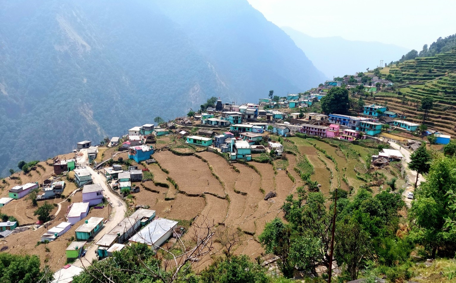
Village 2 — Gangi Village
Altitude: Approximately 2,100 meters. Distance from Ransi: 3 km Distance from Madmaheshwar Temple: 15 km Trek Time from Ransi: 1 to 1.5 hours
Gangi village is the first settlement you reach after leaving Ransi. It is a small Garhwali hamlet of perhaps 15 to 20 houses sitting on a gentle ridge above the Madmaheshwar river valley.
The trail from Ransi to Gangi is the easiest section of the Madmaheshwar trek — relatively flat, with a wide path and beautiful valley views. Most trekkers reach Gangi feeling fresh and confident — which is the right way to start.
What you will find at Gangi: A small tea stall — sometimes two during peak season — where you can get chai, Maggi, and basic snacks. This is the most popular first rest stop on the trek, and the local tea stall owners are known for being warm and chatty with trekkers passing through.
What makes Gangi special: Gangi is one of the last permanently inhabited villages on the Ransi to Madmaheshwar trek route. The traditional stone-and-wood Garhwali architecture of the houses here is remarkably well preserved. If you have time, walk 5 minutes off the main trail into the village itself — the terraced fields, small temple, and mountain views from the village centre are worth it.
After Gangi, the trail enters the dense forest zone, and the nature of the trek changes completely. The village path becomes a jungle path. Enjoy Gangi's open sky and valley views before the trees close in.
Village 3 — Bantoli Village
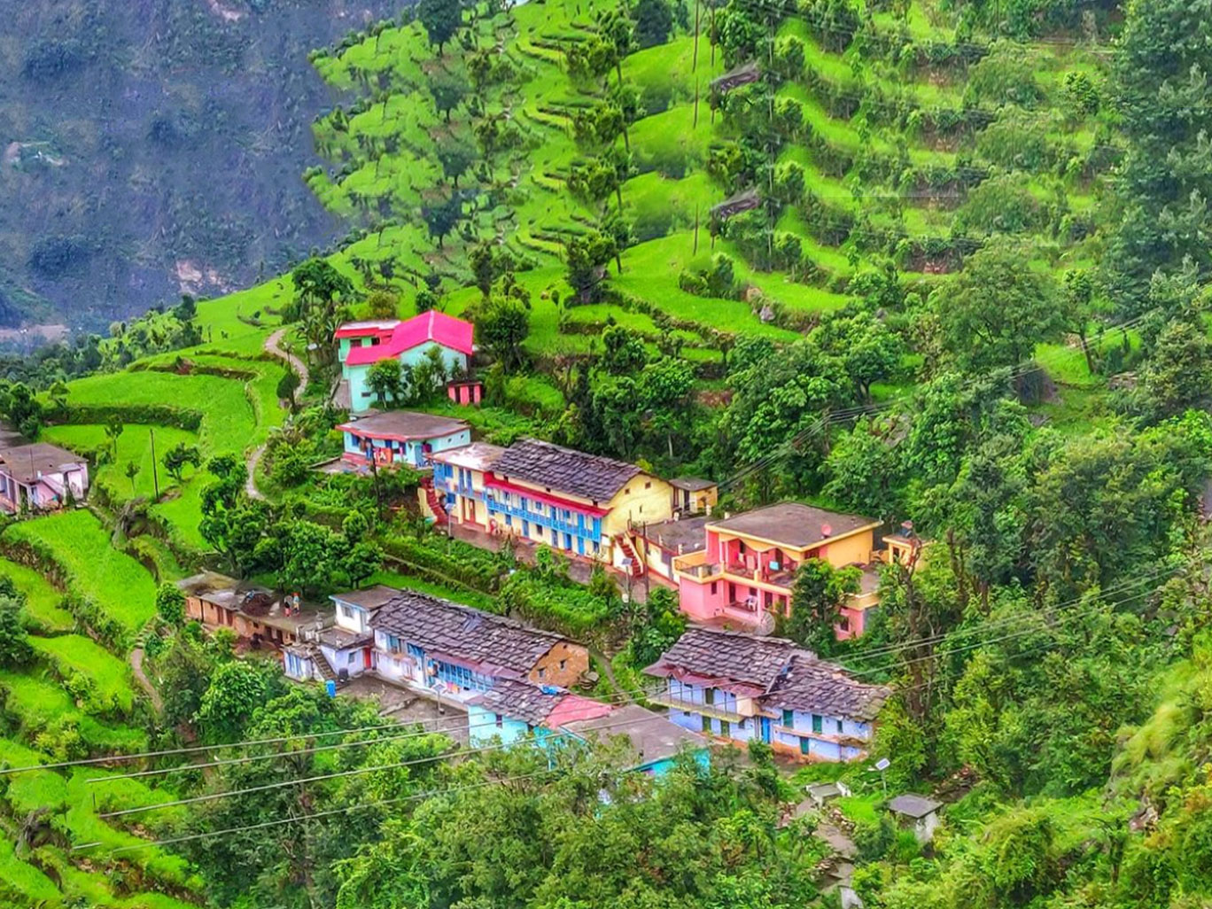
Altitude: Approximately 2,250 meters Distance from Ransi: 11 km Distance from Madmaheshwar Temple: 5 km Trek Time from Ransi: 5 to 6 hours
Bantoli is the most important village on the entire Ransi to Madmaheshwar trek route — the overnight halt for Day 1 and the midpoint of the complete journey.
Arriving at Bantoli after 11 km of forest trekking is one of the most satisfying moments of the trek. The small clearing appears suddenly after a final forested ridge climb — stone houses, smoke, the smell of dal cooking, and the sound of the Madmaheshwar river nearby.
What you will find at Bantoli: A forest rest house bookable through the Ukhimath forest office, a few local homestays run by Garhwali families, basic dhabas serving dal rice roti and chai, and a small open area where trekkers gather in the evening to rest and share stories.
What makes Bantoli special: Bantoli is the heart of the Madmaheshwar trek journey. The forest rest house here is one of the finest spots for stargazing in the Garhwal Himalaya — at 2,250 meters with zero light pollution, the Milky Way is clearly visible on clear nights. The Madmaheshwar river flows just below the village, and the sound of it through the night is deeply peaceful.
The local families of Bantoli who open their homes during trekking season are among the warmest people on this trail. Spending an evening with a Bantoli family — sitting by the kitchen fire, drinking chai, listening to stories about the mountain — is an experience that no hotel stay can replicate.
Bantoli Birding: The forest around Bantoli is one of the best spots on the trek for Himalayan monal sightings. Early morning walks around the village before continuing the trek have rewarded patient birdwatchers with extraordinary wildlife moments.
Village 4 — Khatara Village
Altitude: Approximately 2,600 meters. Distance from Bantoli: 4 km Distance from Madmaheshwar Temple: 3 km Trek Time from Bantoli: 1.5 to 2 hours
Khatara is a tiny settlement between Bantoli and Nanu that most trek guides completely skip. But trekkers who pay attention will notice a handful of stone houses on a small ridge just above the trail — this is Khatara.
What you will find at Khatara: One or two basic tea stalls during peak season. A small natural water source nearby. Basic shelter in case of sudden rain. Not much else — but sometimes not much else is exactly what you need.
What makes Khatara special: Khatara marks the transition zone between the dense forest and the more open subalpine terrain above. The trees begin to thin here, and the first glimpses of open sky and distant snow peaks appear through the forest canopy. For many trekkers, the view from the Khatara ridge on a clear morning is the first hint of the extraordinary panorama waiting at the temple.
Village 5 — Nanu Village
Altitude: Approximately 2,800 meters. Distance from Bantoli: 3 km Distance from Madmaheshwar Temple: 2 km Trek Time from Bantoli: 2.5 to 3 hours
Nanu village is the last human settlement before the Madmaheshwar temple. It sits at 2,800 meters above most of the forest, on the edge of the subalpine zone, with increasingly open mountain views.
What you will find at Nanu: One or two basic tea stalls and simple food during peak season. A small rest area where trekkers stop to catch their breath before the final push. The Madmaheshwar river is crossed twice near Nanu on wooden bridges — these river crossings are one of the most photographed moments on the entire trek route.
What makes Nanu special: From Nanu, the forest officially ends within the next kilometre. After this point, the trail opens dramatically into the Madmaheshwar bugyal. Nanu is where most trekkers take their last proper rest, drink water, eat their last snack, and mentally prepare for the final climb to the temple.
The altitude at Nanu — 2,800 meters — is where some trekkers begin to feel the first effects of altitude. Walk slowly from Nanu. Drink water consistently. The temple is only 6 km away, but those 6 km include the most significant altitude gain of the entire Ransi to Madmaheshwar route.
The Final Stretch — Nanu to Madmaheshwar Temple

Distance: 6 km Altitude gain: 697 meters (2,800 m to 3,497 m) Time: 2 to 2.5 hours
After Nanu, the trail climbs steadily, and the forest gives way completely. The Madmaheshwar bugyal opens up in front of you — wide, green, impossibly beautiful.
And then you see it. The ancient Madmaheshwar temple sits in the middle of the meadow. Kedarnath peak, Chaukhamba, Neelkanth, and Meru are all visible at once above the temple roof.
This moment — after passing through Ransi, Gangi, Bantoli, Khatara, and Nanu — is what every step of this trek was building toward.
Village by Village Distance Summary
| Village | Altitude | Distance from Ransi | Facilities |
|---|---|---|---|
| Ransi | 1,980 m | 0 km | Homestay, shop, check post |
| Gangi | 2,100 m | 3 km | Tea stall, chai |
| Bantoli | 2,250 m | 10 km | Rest house, homestay, food |
| Khatara | 2,600 m | 14 km | Basic tea stall |
| Nanu | 2,800 m | 16 km | Tea stall, river crossing |
| Madmaheshwar Temple | 3,497 m | 18 km | GMVN, Dharamshala |
✅ Want to experience every village on the Ransi to Madmaheshwar route with an expert local guide who knows each settlement personally? Check our Madhyamaheshwar Trek Package 2026 — guided trek, all stays included, starting at ₹7,000 per person.
Helpful Resources for Trek Planning:
- Madmaheshwar Opening Ceremony 2026
- Ransi village to madmaheshwar temple - village by village guide
- Madmaheshwar Trek Package Under ₹8000 – Is It Worth It?
- Madmaheshwar Group Trek vs Private Package – Which Should You Book?
- Madmaheshwar vs Kedarnath Trek: Which One Should You Choose in 2026?
- Madmaheshwar Trek for Families – Is It Safe for Kids & Senior Citizens?
- Kanchani Tal Trek from Madmaheshwar – Complete Guide 2026
- Omkareshwar Temple Ukhimath – Why It's the Soul of Madmaheshwar Yatra
- Madmaheshwar vs Tungnath Trek – Which Panch Kedar is Better for You?
- Madmaheshwar Trek Route Guide
- Madmaheshwar Trek in Monsoon – Landslide Risk & Tips


