
Why Hampta Pass Is Called the Most Dramatic Crossover Trek in India
Published on June 24, 2026
There's a particular moment on the Hampta Pass trek that every trekker remembers — not the summit, not the campsite, but the exact bend in the trail where the scenery simply stops making sense. One side of you is green. The other is brown, cracked, and lunar. Somewhere between Jobra and Shia Goru, India's landscape quietly changes its mind about what it wants to be, and you happen to be standing right in the middle of it.
This is what makes Hampta Pass different from almost every other trek in the Himalayas. It isn't built around a single dramatic peak or a glacial lake reveal. It's built around transformation — a five-day walk that takes you from the lush, forested folds of the Kullu Valley straight into the stark, high-desert terrain of Spiti, with a possible detour to one of the most photographed lakes in India along the way. At TourMyHoliday, we've led groups across this exact route for several seasons now, and it remains one of the few treks where the terrain itself tells the story better than any guide can.
The Trek That Crosses Two Worlds
Most Himalayan treks move you deeper into one kind of landscape — further into a valley, higher into a snowfield, closer to a single destination. Hampta Pass does something rarer: it moves you between two entirely different ecological and geographic zones in the space of a single trek.
You start in Jobra, near Manali, surrounded by dense pine and maple forests, gushing streams, and the unmistakable green-on-green palette of the Kullu Valley. By the time you descend the other side of the pass into Chatru, you're standing in a cold desert — wide open valleys, jagged brown ridgelines, and a silence that feels almost lunar. The Pir Panjal range, which the trail crosses, acts as the dividing wall between the moisture-rich Kullu side and the rain-shadow desert of Lahaul-Spiti. Few treks in India let you witness both sides of a mountain range's climatic effect in a single itinerary.
"Ready to witness this landscape transformation yourself? Check out our Hampta Pass Trek Package with Chandratal extension."
The Green Side: Kullu Valley
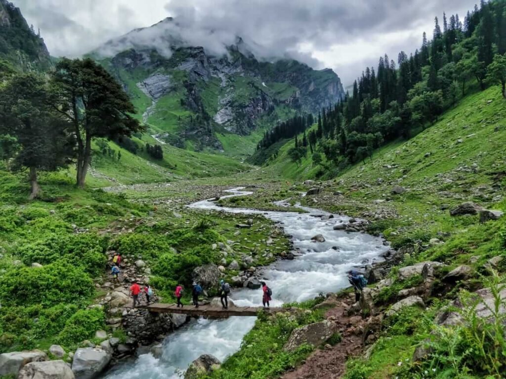
The first two days of the trek are deceptively gentle. From Jobra, the trail climbs gradually through forests of birch, maple, and silver oak before opening into Chika, a riverside meadow that feels more like a postcard than a campsite. The Rani Nallah stream runs alongside much of this stretch, and the meadows here — Jwara and Balu ka Ghera — are carpeted with wildflowers through the monsoon shoulder months.
This section is where the "green" half of Hampta Pass's dual identity lives. Tall grass, grazing sheep, the occasional shepherd's camp, and a river that you'll cross — sometimes on a log bridge, sometimes wading through icy water that takes your breath away — define these first days. It's also where most first-time trekkers underestimate just how different the trek is about to become.
The River Crossings
Hampta Pass is known among trekking communities for its river crossings, and they're not a footnote — they're part of the trek's identity. The crossings near Chika and again closer to Balu ka Ghera can swell dramatically depending on glacial melt and recent rainfall, sometimes requiring trekkers to form human chains or rely on local guides who know the safest fording points. Snow bridges, common earlier in the season, can also collapse later in summer, which is part of why route knowledge and timing matter so much on this particular trek.
These crossings aren't just an obstacle — they're a reminder that this trail is alive and changes week to week, which is part of what keeps experienced trekkers coming back season after season.
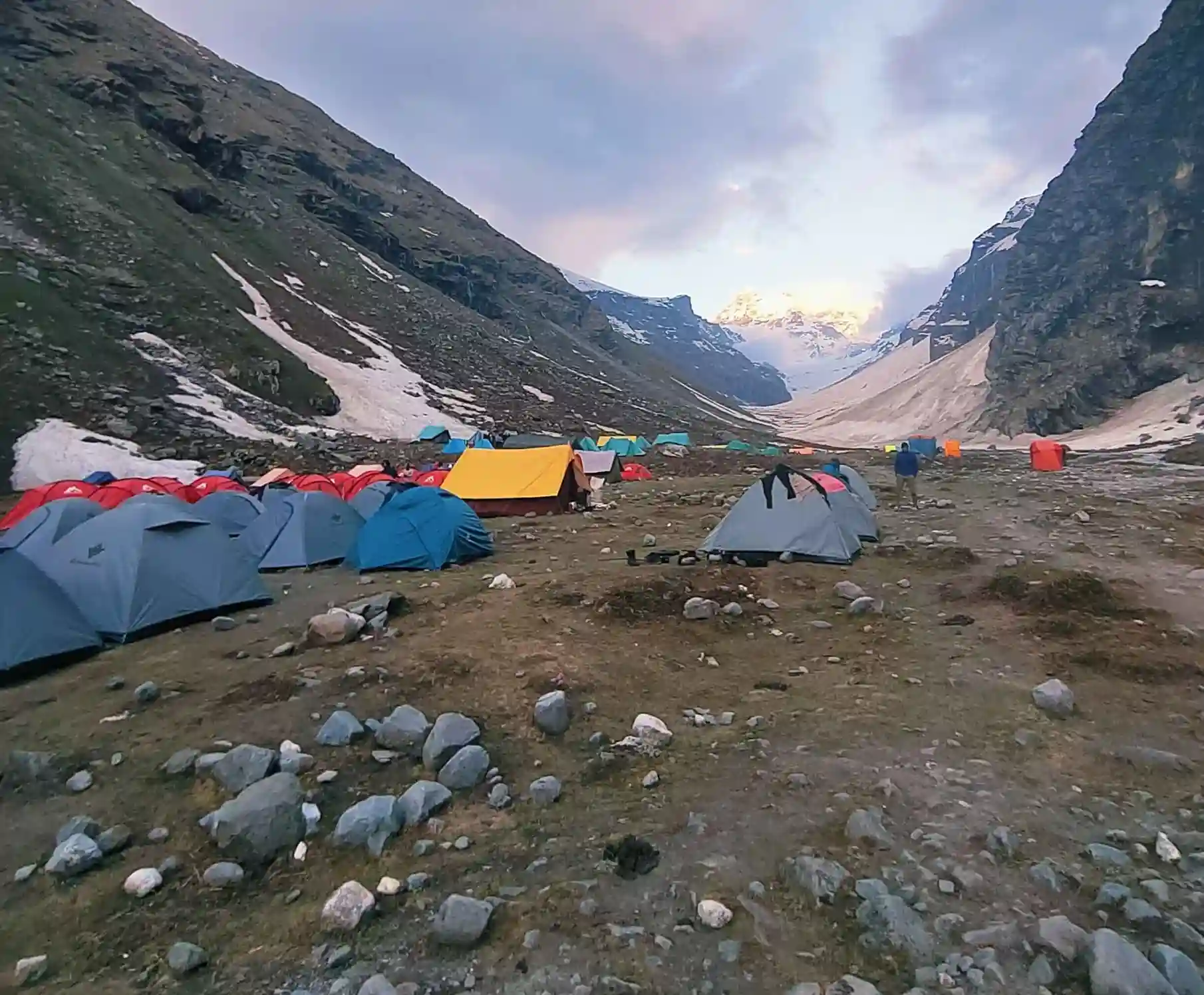
The Climb to the Pass — and the Snow Patches
The push to Hampta Pass itself, at roughly 4,270 m, is the trek's most physically demanding stretch. The trail steepens noticeably after Balu ka Ghera, and even in peak summer, snow patches persist near the top — often requiring microspikes or trekking poles for grip. Depending on the year and snowfall, trekkers can encounter anything from a few patches to a near-complete snow cover at the pass itself.
It's at the top of Hampta Pass that the "crossover" becomes visible in a single glance. Looking back, the Kullu side is layered in green ridgelines and clouds. Looking ahead, the Lahaul-Spiti side unfolds in shades of brown, grey, and gold, with the Chandra River valley visible far below. Photographers and first-time trekkers alike tend to stop here longer than planned — it's one of the few vantage points in Indian trekking where you can frame both ends of a climate transition in the same photograph.
"Let TourMyHoliday plan your crossover trek end-to-end — View Hampta Pass Trek Packages and book your dates today."
The Brown Side: Descending into Spiti's Cold Desert
The descent into Shea Goru and onward to Chatru marks the trek's second identity. Vegetation thins out almost immediately. The Chandra River, fed by the Chandra-Bhaga glacier system, carves a wide, braided path through a valley that looks more like Ladakh than anything typically associated with Himachal. Wind erosion has shaped the surrounding ridges into sharp, almost sculptural forms, and the temperature swing between day and night becomes noticeably sharper.
This is the terrain most trekkers come to Hampta Pass for — not because it's prettier than the green side, but because of how abrupt and total the change feels after just one mountain pass.
The Chandratal Connection
No description of Hampta Pass is complete without mentioning Chandratal — the crescent-shaped high-altitude lake that many itineraries include as an extension from Chatru or Batal. Sitting at around 4,300 m, Chandratal's still, glacial-blue water reflects the surrounding peaks with a clarity that has made it one of the most photographed lakes in the Himalayas.
While Chandratal isn't technically part of the original Hampta Pass route, the proximity has made it a near-standard add-on, and for good reason: after days of crossing a transforming landscape, ending the trip at a lake this serene feels like a deliberate final note rather than an afterthought. Most well-structured Hampta Pass itineraries — including the ones we run — build in a night near Chandratal for exactly this reason.
Why This Landscape Shift Happens
The dramatic visual change across Hampta Pass isn't a coincidence of scenery — it's a textbook example of the rain-shadow effect. The Pir Panjal range blocks monsoon moisture from reaching Lahaul-Spiti, which is why the Kullu side stays green and forested while the other side remains arid and desert-like even in peak monsoon months. Understanding this is part of what makes the trek so compelling for trekkers who want more than just a scenic walk — it's a hands-on geography lesson written into the land itself.
Best Time to Trek Hampta Pass
The trekking season typically runs from mid-June to early September, with conditions shifting noticeably within that window:
- Mid-to-late June: Heavy snow patches, dramatic but more technical river crossings.
- July–August: Lush green meadows on the Kullu side, wildflowers in bloom, and the clearest contrast with the Spiti side.
- Late August–early September: Drier trail, calmer river crossings, and excellent visibility for landscape photography.
Each window changes the character of the photographs you'll come home with, which is worth factoring in if the visual transformation is your main reason for choosing this trek.
Planning Your Hampta Pass Trek
A typical Hampta Pass itinerary runs 4–5 days for the core trek, often extended to 5–6 days with the Chandratal add-on. Acclimatisation at Jobra or Chika, proper river-crossing gear, and a guide familiar with current snow and water conditions all matter more here than on a typical out-and-back Himalayan trek, given how much the trail's character shifts within the same itinerary.
If you're drawn to this trek for the same reason most trekkers are — that rare chance to watch an entire landscape change character mid-walk — having a team that knows the current trail and river conditions makes a real difference to both safety and the experience itself.
Frequently Asked Questions
1. Why is Hampta Pass called a "crossover" trek?
Hampta Pass is called a crossover trek because it connects two completely different landscapes — the green, forested Kullu Valley and the arid, desert-like terrain of Lahaul-Spiti — within a single 4–5 day trek across the Pir Panjal range.
2. How difficult are the river crossings on the Hampta Pass trek?
The river crossings near Chika and Balu ka Ghera can range from simple wades to more challenging crossings, depending on glacial melt and recent rainfall, often requiring guided assistance or human chains during peak flow periods.
3. Can Chandratal be included in the Hampta Pass trek?
Yes, Chandratal is commonly added as an extension from Chatru or Batal, and most well-planned itineraries include a night near the lake as the trip's closing leg.
4. Is there snow on the Hampta Pass trek in summer?
Snow patches are common near the pass itself, even during peak summer months, with the extent varying year to year based on seasonal snowfall.
5. What is the best time to see the landscape contrast on Hampta Pass?
July and August offer the clearest contrast, with lush green meadows on the Kullu side and dry, brown terrain on the Spiti side visible in the same trek.
6. How long is the Hampta Pass trek?
The core trek typically takes 4–5 days, often extended to 5–6 days when combined with the Chandratal extension.
7. Do I need prior trekking experience for Hampta Pass?
Hampta Pass is considered moderate in difficulty, suitable for fit beginners, though some prior trekking or fitness experience helps, particularly for the river crossings and the steep push to the pass.
Helpful Resources for Trek Planning:
- Trekking in Uttarakhand: Routes, Difficulty, Best Time & Tips
- Madhyamaheshwar Temple Trek from Ransi Village
- Buda Madmaheshwar Complete Guide 2026
- Madmaheshwar Trek Route Guide
- Madmaheshwar Trek in May: Complete Guide
- Madmaheshwar vs Kedarnath Trek: Which One Should You Choose in 2026?
- Madmaheshwar vs Tungnath Trek
- Madmaheshwar vs Rudranath Trek
- Madhyamaheshwar Yatra 2026:Complete Guide
- Madmaheshwar trek full itinerary 2026
- Madmaheshwar Trek in June: Complete Guide
- Madmaheshwar Trek in Monsoon – Landslide Risk & Tips (2026 Complete Guide)


