Tehri Lake
Published on February 04, 2025
Tehri Lake, located in the Garhwal region of Uttarakhand, is one of the largest artificial lakes in India. It came into existence after the construction of the Tehri Dam on the Bhagirathi River, a major tributary of the Ganga. Today, Tehri Lake is not only a water reservoir but also a symbol of both human achievement and sacrifice. On one hand, it provides electricity, drinking water, irrigation, and flood control to millions of people. On the other hand, it submerged the old town of Tehri and many surrounding villages, displacing more than one lakh people.
The lake did not exist naturally. Its origin is directly linked to the planning and execution of the Tehri Dam project, which began in the mid-20th century and was completed in the early 21st century. The story of Tehri Lake is, therefore, deeply tied to India’s post-independence development goals, environmental debates, and social challenges. To understand Tehri Lake, one must first look at the historical background of the Tehri region, the idea of the dam, and the long journey that led to the creation of this massive water body.
The Historical Background of the Tehri Region
Before the lake came into existence, there was Old Tehri town, the capital of the erstwhile Tehri Garhwal kingdom. The word “Tehri” is derived from “Trihari,” meaning a place that cleanses three types of sins—of thought, word, and deed. This gives an idea of how important and spiritual this land was for the people living here.
The region of Garhwal had been ruled by many small kings. In the 18th century, King Sudarshan Shah established Tehri as the capital of his kingdom. The town was strategically located at the confluence of the Bhagirathi and Bhilangana rivers. This location later became the very site chosen for the Tehri Dam.
During the 19th century, after the defeat of the Gorkhas, Garhwal was divided between the British and the Tehri king. The British controlled Kumaon and some parts of Garhwal, while Tehri remained under the rule of its monarchs. After India’s independence in 1947, the kingdom of Tehri was merged into the Indian Union in 1949. The old town of Tehri continued to exist until the late 20th century, when it was finally submerged under the waters of the new reservoir.
Thus, the historical Tehri town, which once saw kings, battles, and cultural growth, became the foundation for a modern engineering marvel that changed the landscape forever.

The Early Idea of Tehri Dam
The concept of a dam on the Bhagirathi River first came up in the 1940s when engineers began to study the Himalayan rivers for hydropower and irrigation projects. However, it was only in 1961 that a detailed survey and investigation were carried out for a dam near Tehri.
In the early decades of independent India, large dams were considered “temples of modern India,” a phrase famously used by Prime Minister Jawaharlal Nehru. The government saw dams as a way to achieve multiple goals at once—hydropower, irrigation, flood control, and water supply.
By 1972, the design for the Tehri Dam was approved. The original plan was for a 600 MW hydropower project. However, as technology advanced and needs increased, the capacity was later revised to 2,400 MW in stages.
The dam was not only about electricity. It was also planned to supply drinking water to cities like Delhi, provide irrigation to thousands of hectares of farmland in Uttar Pradesh, and regulate floods in the Ganga basin. With such wide-ranging benefits, the Tehri Dam project was considered a project of national importance.
Timeline of Construction
The journey from idea to completion was long and full of challenges.
-
1961 – Detailed survey and investigation of the dam site completed.
-
1972 – Official approval of the project design.
-
1978 – Actual construction work began.
-
1986 – The Soviet Union (USSR) offered technical and financial assistance.
-
1988 – The Tehri Hydro Development Corporation (THDC) was created to manage the project.
-
1990s – Intense protests and environmental debates slowed down construction.
-
2001–2004 – Final stages of construction took place.
-
2006 – The dam was commissioned, and the reservoir started filling, submerging the old Tehri town.
This timeline shows how the project took more than four decades from survey to completion, making it one of the most debated and delayed projects in India’s history.
Engineering Marvel of Tehri Dam
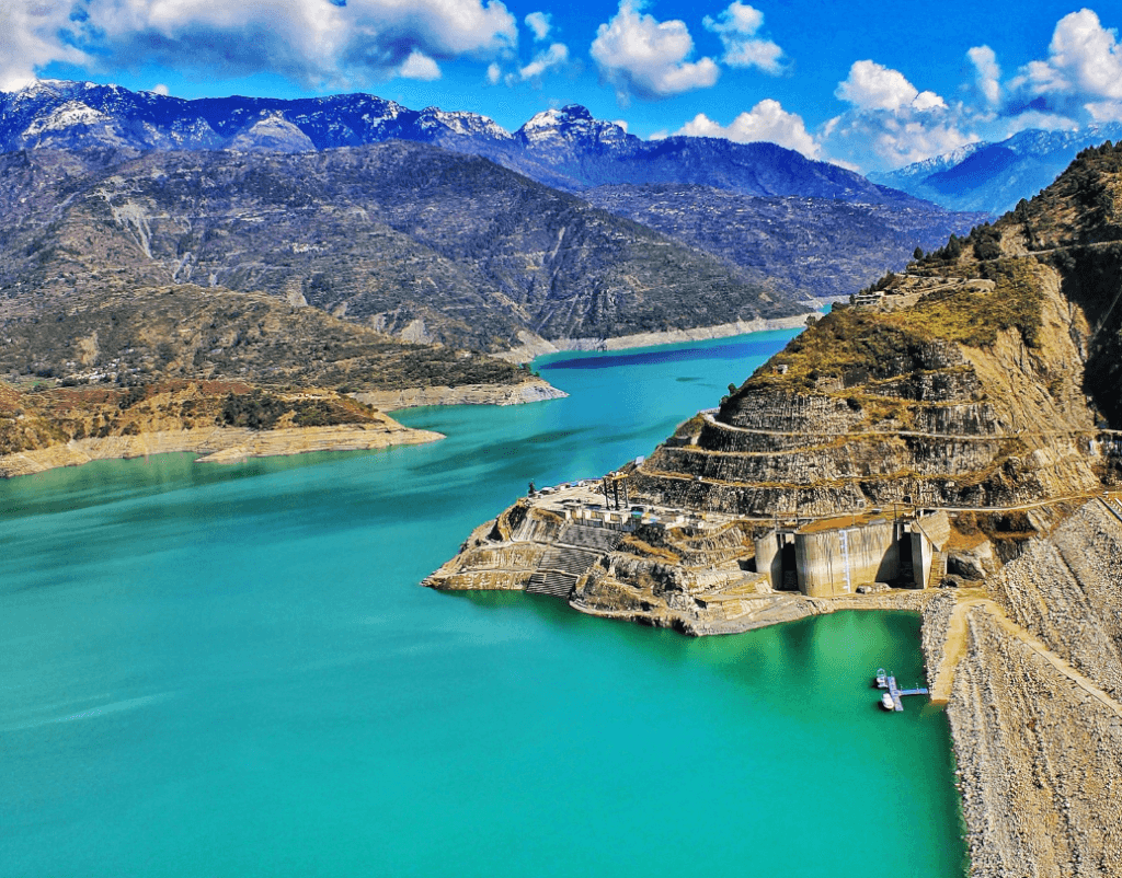
Tehri Dam is the tallest dam in India and one of the tallest in the world. It is an earth-and-rock-fill embankment dam, standing 260.5 meters (855 ft) high. Its length is about 575 meters, and its base is more than 1,100 meters wide.
The dam was designed with modern earthquake-resistant technology, as the region lies in a high seismic zone. This was one of the biggest concerns raised by critics, but engineers ensured that the dam could withstand even strong earthquakes.
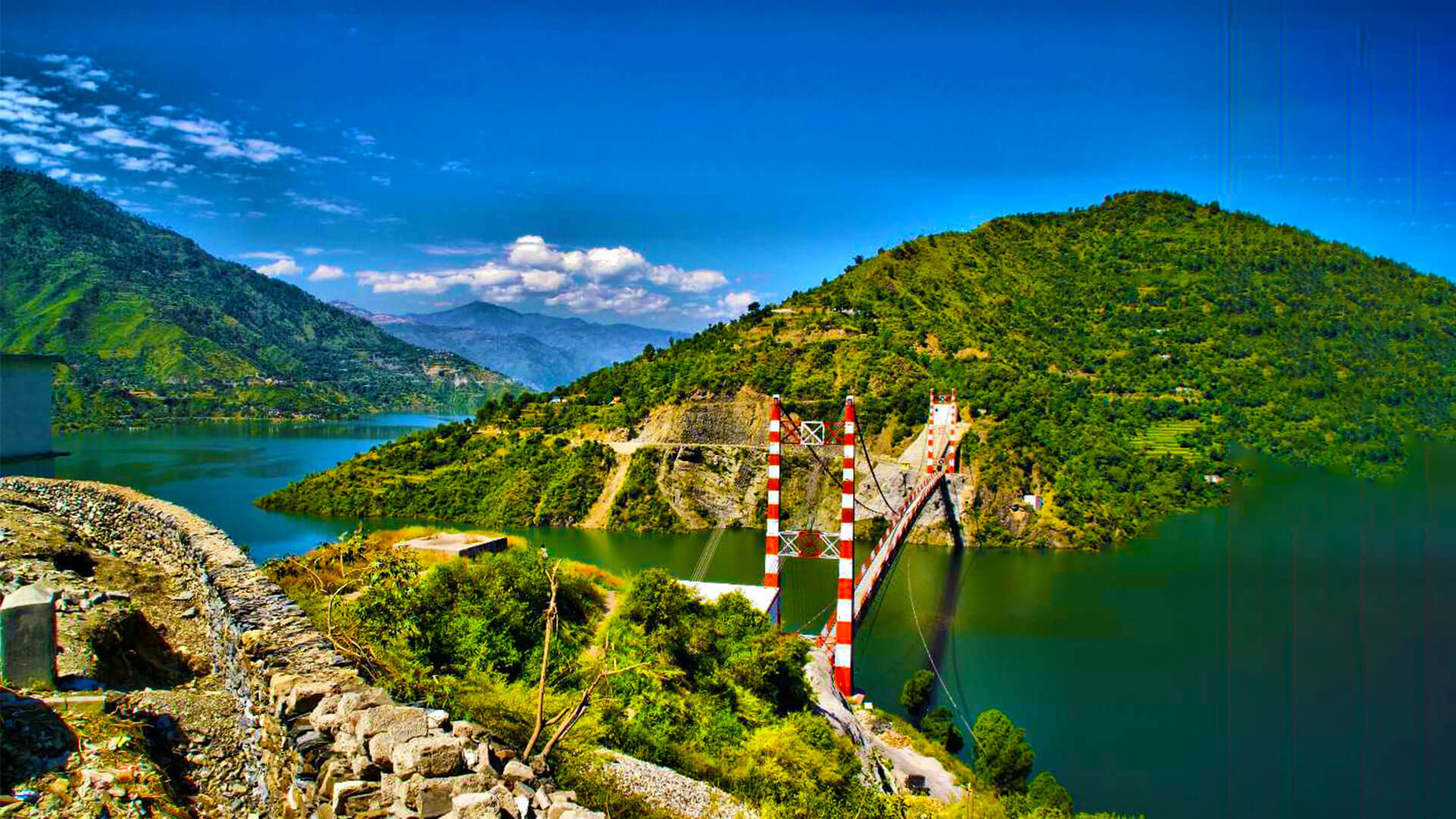
The reservoir created by the dam, known as Tehri Lake, holds nearly 3.54 cubic kilometres of water and spreads across 42–52 square kilometres of surface area. This vast body of water completely transformed the landscape of the Bhagirathi valley.
Formation of Tehri Lake
Tehri Lake was formed when the waters of the Bhagirathi River were blocked by the dam, leading to the submergence of Old Tehri town and several villages. Slowly, as the reservoir filled, the valley turned into a massive water body surrounded by the Himalayan hills.
This lake did not exist in nature before. It is purely man-made, created for power generation, irrigation, and water supply. The creation of Tehri Lake also marked the disappearance of a centuries-old town and the relocation of thousands of families.
Social Impact – Displacement and Resettlement
The making of Tehri Lake came at a high social cost. Nearly 100,000 people from Old Tehri and surrounding villages were displaced. More than 24 villages were completely submerged, and around 88 villages were partially affected.
The people were relocated to areas like New Tehri, which was specially built to rehabilitate them. However, many displaced families complained about inadequate compensation, lack of proper facilities, and loss of cultural ties to their ancestral land.
For the older generation, leaving behind temples, schools, farms, and ancestral homes was a painful experience. For younger people, it meant adjusting to a new life in an urban-style settlement away from their traditional rural surroundings.
Environmental Concerns and Protests
The Tehri Dam project faced some of the strongest environmental protests in India. Sunderlal Bahuguna, a famous environmentalist and leader of the Chipko Movement, was one of the most vocal critics of the dam. He argued that building such a massive structure in an earthquake-prone Himalayan zone was dangerous. He also highlighted the ecological loss caused by submerging forests, fertile land, and the sacred flow of the Bhagirathi (a tributary of the holy Ganga).
Religious leaders also opposed the dam, fearing it would disrupt the sanctity of the Ganga River. Environmental groups pointed out risks such as landslides, sedimentation, and the possibility of dam failure in case of a major earthquake.
Despite protests, hunger strikes, and legal challenges, the project went ahead, backed by the government as a necessity for development.

Benefits of Tehri Lake and Dam
While the human and ecological costs were high, the benefits of the dam are also undeniable:
-
Hydropower: The dam generates about 1,000 MW of electricity from its first phase. With pumped storage and downstream projects, the total capacity is expected to reach 2,400 MW.
-
Irrigation: Provides water for nearly 270,000 hectares of new agricultural land and stabilises irrigation for more than 600,000 hectares.
-
Drinking Water: Supplies clean drinking water to millions of people in Delhi, Uttar Pradesh, and Uttarakhand.
-
Flood Control: Helps regulate floods in the Ganga basin by controlling the flow of water.
Tehri Lake Today
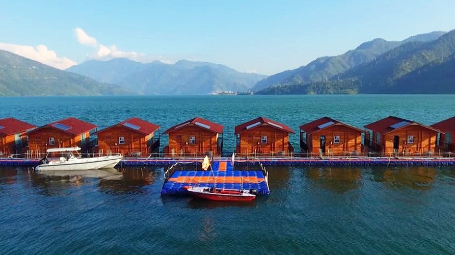
Today, Tehri Lake is more than just a reservoir. It has become a hub for tourism and water sports. Activities like boating, jet skiing, parasailing, and water zorbing attract visitors from across India. The Tehri Lake Festival celebrates adventure sports, local culture, and the natural beauty of Uttarakhand.
The lake has also become a symbol of how a development project, despite its controversies, can be turned into an opportunity for regional growth.
The story of Tehri Lake is a story of transformation. From a quiet Himalayan valley with a historic town, it turned into one of India’s largest man-made lakes. Its origin lies in India's ambitious vision for post-independence development, to harness rivers for growth. Its history is marked by decades of planning, protests, construction challenges, displacement, and finally, completion.
Tehri Lake stands today as a reminder of the complex balance between development and human cost. It represents both loss and progress—loss of old Tehri town and ancestral lands, but also progress in the form of power, water, and new opportunities.
Tehri Lake: The Himalayan Emerald Sea (2026 Ultimate Guide)
Tehri Lake (officially Maharaja Narendra Shah Lake) is India’s largest high-altitude man-made reservoir, a breathtaking 42 km-long turquoise jewel floating at 1,700 m in the Garhwal Himalayas. Created by the 260.5 m tall Tehri Dam on the Bhagirathi River, it drowned the old Tehri town in 2006 and gave birth to one of the most dramatic water bodies in the country. Surrounded by 360° snow peaks, dense pine forests, and terraced villages, it has quietly become North India’s premier destination for houseboats, water sports, and offbeat mountain sunsets.
Location & Key Facts (2026)
- District: Tehri Garhwal, Uttarakhand
- Altitude: 1,550–1,800 m (water level fluctuates 60 m yearly)
- Surface area: 52 km² (at full reservoir level)
- Maximum depth: ~260 m near the dam wall
- Distance from major cities: – Delhi: 310 km (7–9 hrs) – Rishikesh: 110 km (3.5–4 hrs) – Dehradun: 135 km (4–5 hrs) – New Tehri town: 15–20 km
How to Reach Tehri Lake (2026)
Best route from Delhi Delhi → Meerut bypass → Muzaffarnagar → Roorkee → Chamba → New Tehri → Koti Colony jetty (310 km)
Public transport
- Overnight Volvo from Delhi ISBT to Rishikesh → shared taxi to Chamba → local bus/taxi to Koti Colony jetty (₹800–1,200 total)
By train
- Nearest major station: Haridwar (90 km) or Dehradun (135 km)
By air
- Jolly Grant Airport, Dehradun → 4 hr taxi (₹3,500–4,500)
Weather & Best Season (2026)
| Season | Temperature | Water Level | Recommendation |
|---|---|---|---|
| March–June | 15–32°C | Rising | BEST time – houseboats + water sports |
| July–September | 18–28°C | Full (monsoon) | Lush green, occasional roadblocks |
| October–November | 10–25°C | High & clear | Perfect visibility, golden sunsets |
| December–February | 0–18°C | Lowest | Winter houseboats, misty mornings |
Top Things to Do at Tehri Lake (2026)
- Houseboat Stay – floating luxury with snow-peak views
- Jet ski & speed boating – 30+ boats now operating
- Shikara sunset ride – the Garhwal version of Dal Lake
- Kayaking & paddle boarding – calm bays perfect for beginners
- Asia’s highest jetty zipline – 1.2 km long, 200 m above water (₹1,500)
- Scuba diving – 2025 certified centre at Koti Colony (₹4,000/dive)
- Paragliding – take-off from Pratap Nagar ridge, landing on a floating platform
- Trekking – 14 surrounding trails (Pantwari–Nag Tibba, Kaddukhal, Devladhar)
Houseboats & Floating Accommodation (2026 prices)
| Name | Type | Price/night (2 pax) | Highlights |
|---|---|---|---|
| The Floating Himalaya Hut | Luxury houseboat | ₹12,000–18,000 | Glass roof, jacuzzi, chef |
| Tehri Lake Resort (floating) | Mid-range houseboat | ₹7,000–11,000 | 4 rooms, restaurant |
| Aqua Floating Huts | Budget houseboat | ₹4,500–7,000 | Basic but clean, great views |
| Lakeview Camps (on shore) | Luxury tents | ₹5,000–9,000 | Private jetty, bonfire |
Entry Fees & Activities Cost (2026)
| Activity | Price (per person) |
|---|---|
| Jetty entry + parking | ₹50 |
| Speed boat (15 min) | ₹400–600 |
| Jet ski (10 min) | ₹800–1,200 |
| Shikara ride (1 hr) | ₹1,200–1,800 |
| Zipline | ₹1,500 |
| Scuba dive | ₹4,000 |
Infrastructure & 2026 Updates
- New 4-lane tunnel (Chamba bypass) opened Jan 2025 – saves 45 min
- Floating fuel station for boats (first in India)
- 24×7 floating police patrolling
- 5G towers installed on both shores
- Eco-toilets & waste segregation boats
Safety Tips
- Life jackets mandatory (strictly enforced in 2026)
- No swimming allowed (depth + cold shock)
- Monsoon road blocks are common – check HRTC updates
- Altitude sickness is rare but possible (1,700 m)
Q: Is it safe to visit during the monsoon?
A: Yes for lake activities (water is calmer), but roads can be blocked for 1–2 days.
Q: Can we do a day trip from Rishikesh?
A: Possible but rushed. Better overnight for the houseboat sunset.
Q: Alcohol allowed on houseboats?
A: Yes on private boats (BYOB), not on public jetties.
Q: Best month for mirror-like reflections?
A: October–November – zero wind, perfect glass surface.
Q: Any fish in the lake?
A: Yes – mahseer, trout, carp. Fishing is allowed with a permit (₹500/day).
If you are planning a trip to Tehri Lake, it is a great idea to explore nearby offbeat destinations in Uttarakhand that offer both adventure and spirituality. One of the most beautiful hidden gems you can include in your journey is the Madhmaheshwar Trek, a perfect destination for travellers looking for peace, nature, and a divine experience in the Himalayas.
Madhmaheshwar is one of the sacred Panch Kedar temples dedicated to Lord Shiva and holds great religious significance among devotees. Located in the Garhwal region of Uttarakhand, this trek takes you through dense forests, alpine meadows, and scenic mountain landscapes, making the journey as beautiful as the destination itself. The temple is situated at an altitude of around 3,289 meters and offers stunning views of Chaukhamba peaks, making it a must-visit place for trekking enthusiasts and spiritual seekers.
The Madhmaheshwar trek is considered a moderate-level trek and is ideal for both beginners and experienced trekkers. The route passes through beautiful villages like Ransi and Gaundar, where you can experience the local culture and hospitality of Uttarakhand. Unlike crowded destinations like Kedarnath, Madhmaheshwar remains less explored, which makes it perfect for travellers who want to avoid heavy rush and enjoy a peaceful Himalayan environment.
If you are already visiting Tehri Lake, combining it with Madhmaheshwar can make your trip more diverse and memorable. While Tehri Lake offers adventure activities like boating, jet skiing, and camping, Madhmaheshwar adds a spiritual and trekking experience to your itinerary. This combination creates a perfect Uttarakhand travel plan that includes adventure, nature, and devotion.
???? You can explore our Madhmaheshwar Tour Package from Delhi, which includes transportation, accommodation, meals, and guided trekking support. This package is designed for travellers who want a hassle-free and well-organised trip to one of the most peaceful destinations in Uttarakhand.
The best time to visit Madhmaheshwar is from May to June and September to October when the weather is pleasant, and the views are crystal clear. During these months, the trekking route is surrounded by greenery and offers breathtaking views of snow-covered peaks. It is always recommended to travel with proper planning, especially for trekking routes, to ensure a safe and comfortable journey.
Whether you are an adventure lover, nature enthusiast, or spiritual traveller, Madhmaheshwar is a destination that offers a unique and fulfilling experience. Adding this trek to your Tehri Lake trip not only increases the value of your journey but also helps you explore the true beauty of Uttarakhand beyond the usual tourist places.